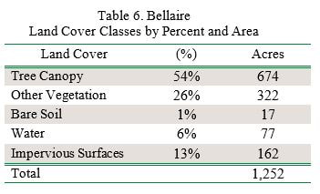
Bellaire’s tree canopy is 54%, which is high relative to many other Michigan communities. Other vegetation comprises 26% of the land cover (Table 6). Impervious surfaces (buildings and roads) make up 13% of the land cover. The outskirts of the village, particularly in the southern and western areas, have the greatest canopy cover (Figure 2), while the areas along the main streets in the downtown area—particularly along Cayuga and Broad Street—have the greatest amount of impervious surfaces (Figure 2).
All maps for this village can be found in the Story Map. Some of the maps are illustrated below to feature village canopy interests.
Looking at canopy in the right-of-way of the, some of the streets with the least canopy include South Division Street, Stover Road, and the block of Cayuga and East Broad Street where the County Court House is located. The areas that contain the highest priority levels for tree planting are concentrated on East Broad Street and East Cayuga Street, as well as the area of South Bridge Street located south of Cayuga Street.

The planting priority levels map layer of the (Figure 2) can be used to hone in on the locations in which plantings may deliver the most benefits in terms of ecosystem benefits and overall benefits to the community. Bellaire can use this as a guideline for deciding where future trees can be planted to have the greatest impact on benefits and stormwater runoff. Of the 253 plantable acres, 51% of those acres (130 acres) are listed as Very High or High planting priority. If only the Very High and High priority planting areas are planted, Bellaire could achieve 64% tree canopy.
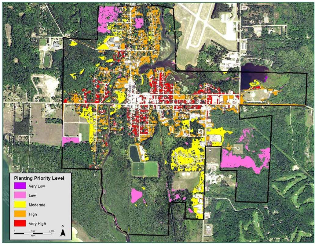
Figure 2. Bellaire prioritized planting areas.
Tree canopy percent by census block analysis found below can be used as a supplemental tool to determine which neighborhoods are in most need of planting (Figure 3). For Bellaire, the tree canopy percent analysis largely confirms the results of the planting priority analysis, where it is shown that the commercial and residential areas between Cayuga and Broad Street, as well as the residential blocks north of Broad Street, are in highest need of an increase in canopy cover. The tree canopy percentage ranges from 0% to 20% in many of the census blocks in this area.
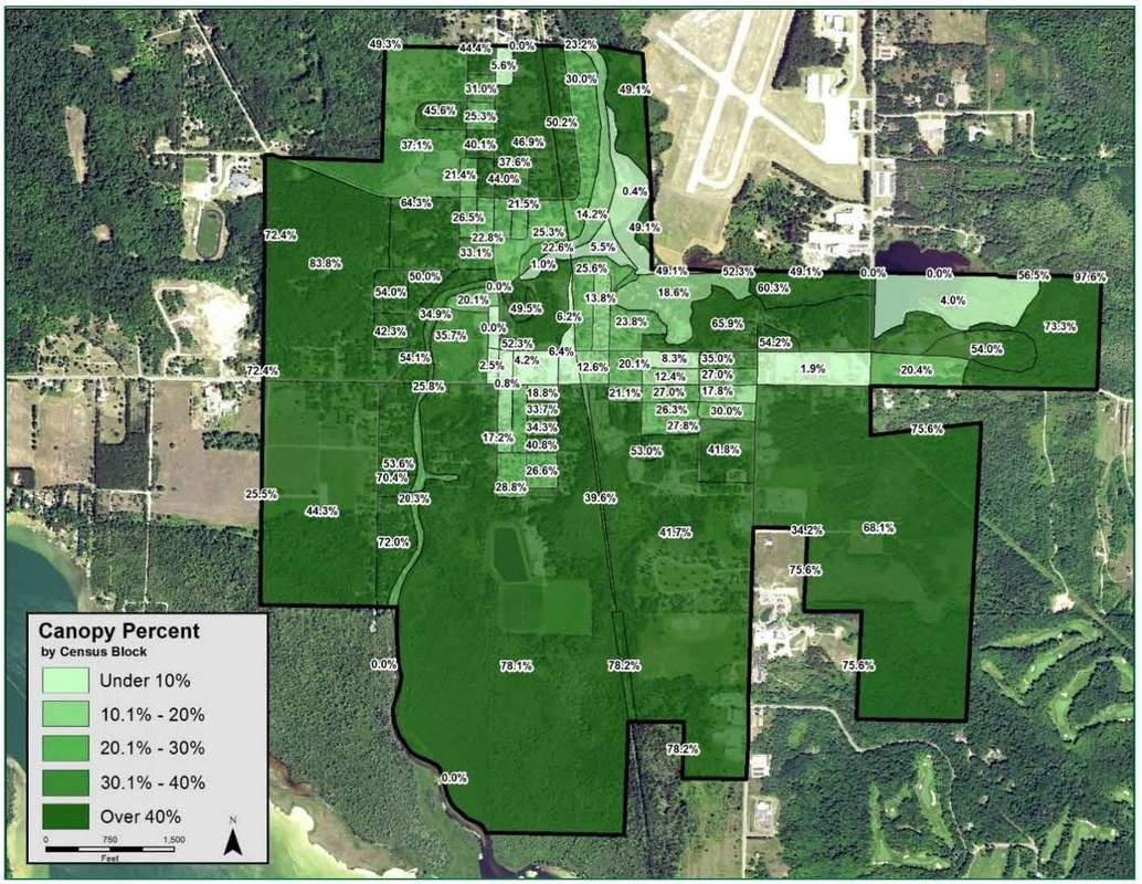
Figure 3. Bellaire tree canopy by census block.
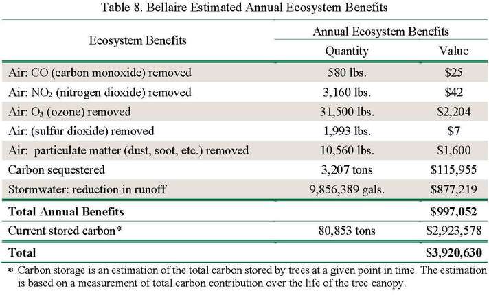
Community forests are important components of the ecosystem and provide quantifiable benefits. Bellaire realizes an annual benefit of $997,052 for reductions in air pollution, stormwater reduction, and carbon sequestration from the tree canopy. The village also benefits from carbon stored in the trees, which contributes $2,923,578 over their lifetime.
Community forests are important components of the ecosystem and provide quantifiable benefits. Bellaire realizes an annual benefit of $997,052 for reductions in air pollution, stormwater reduction, and carbon sequestration from the tree canopy. The village also benefits from carbon stored in the trees, which contributes $2,923,578 over their lifetime.
Management of vegetation near airport runways is a critical component to creating a safe takeoff and landing environment for pilots. There was a change in regulations that allowed for planes to fly lower on the approach and takeoff near airports. As a result, in approximately 2009, the Antrim County airport reduced the height of many trees and removed other trees in the Village of Bellaire that were in the new, lower flight path. A change in canopy analysis was performed for this area of the village to determine how much canopy was lost as a result of this event. To ensure canopy prior to the flight path tree clearing was used, 2005 imagery was used and compared to 2016 imagery. Contrary to expectations, tree canopy coverage in the neighborhood located south of Antrim County Airport rose from 7.87 acres in 2005 to 9.19 acres in 2016 (Figure 4).
That canopy distribution is different in some specific locations, but the overall canopy increased during that time. Areas where tree canopy increased during that period include the shores of the Intermediate river south of the airport, parts of Portage Drive, East Broad Street near the corner of Maple Street, and East Broad Street near Birch Street. Tree canopy decreased during the eleven-year period along Elm Street, Maple Street, and Beech Street north of East Broad Street and along Alley #1 between Elm Street and Beech Street. It appears that much of this canopy increase is due to small trees increasing in size and canopy. These trees may have appeared as low-lying vegetation in 2005, having then grown into trees in 2016. These canopy increases are due to natural succession and growth. The areas that had trees removed or heavily trimmed for airport clearance would have also had increased canopy over this 11-year period had the airport tree maintenance not been necessary. To avoid future tree maintenance and removal and comply with clearance requirements near the airport, species chosen for this area need to be less than 50 feet tall at maturity.
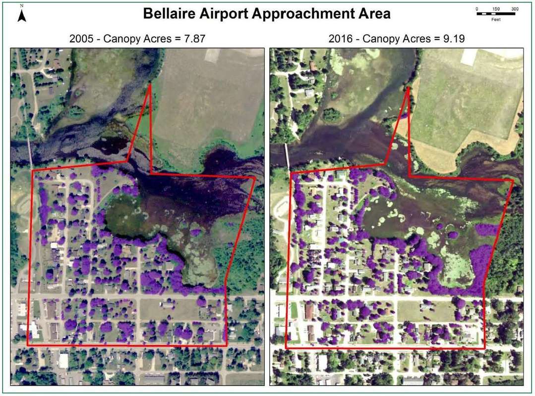
Figure 4. Bellaire canopy change near airport between 2005 and 2016.
Takeaway. The village and residents can focus on improving the areas that suffered canopy loss by planting more trees to increase canopy coverage. Most of the neighborhood near the airport is included in the area noted as having High and Very High planting priority. The Recommended Tree Species List for Grand Traverse Bay should be used when choosing species. Species selection is important and should not include any species that will exceed 50 feet at maturity so as not to interfere with the new flight path.
