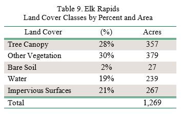
Elk Rapids’ tree canopy (28%) (35% if you exclude the open water) is average compared to other Michigan communities. The southern areas of the village have the greatest canopy cover, while the main thoroughfares have the least canopy cover along the ROW and on private property. Although the highest amount of impervious area (area covered by buildings and roads) is along the main thoroughfares and in the north central area of the community, these areas also contain some of the highest priority levels for tree planting.
All maps for this village can be found in the Story Map. Some of the maps are illustrated below to feature village canopy interests.
Some of the streets with the least canopy along the ROW include US 31 and Bridge Street which run north and south through the village and in the northern part of the village, Dexter Street, Ames Street, North Bayshore Drive, EC Loomis Industrial Park Drive, Lake Street, and Ames Street.
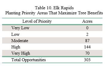
The planting priority levels map layer can be used to focus in on the locations in which plantings may deliver the most ecosystem benefits and overall benefits to the community. Elk Rapids can use this as a guideline for deciding where future trees can be planted to have the greatest impact on benefits and stormwater runoff. Of the 303 plantable acres, 70% of those acres (214 acres) are listed as Very High or High planting priority. If only the Very High and High priority planting areas are planted, Elk Rapids could achieve as much as 45% tree canopy.
The tree canopy percent by census block analysis (Figure 5) can be used as a supplemental tool to determine which neighborhoods are in most need of planting. For Elk Rapids, the tree canopy percent analysis largely reveals the commercial and residential areas are in highest need of an increase in canopy cover.

Figure 5. Elk Rapids tree canopy by census block.
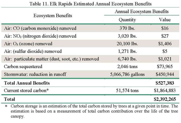
Elk Rapids realizes an annual benefit of $527,383 for reductions in air pollution, stormwater reduction, and carbon sequestration from tree canopy. The village also benefits from carbon stored in the trees. Carbon storage contributes $1,864,883 over the lifetime of the trees.
Elk Rapids storm sewers are designed to move excess water from some areas of the community into the greater watershed and eventually the Grand Traverse Bay. However, Elk Rapids storm sewers are limited to the downtown areas of the village. Areas without sewers are susceptible to flooding due to poor drainage in the clay soils. Elk Rapids can better manage stormwater in clay soils by utilizing trees as part of the green infrastructure. Choosing the appropriate trees for the soil pH and drainage will produce trees that can thrive under these conditions and assist with stormwater management.
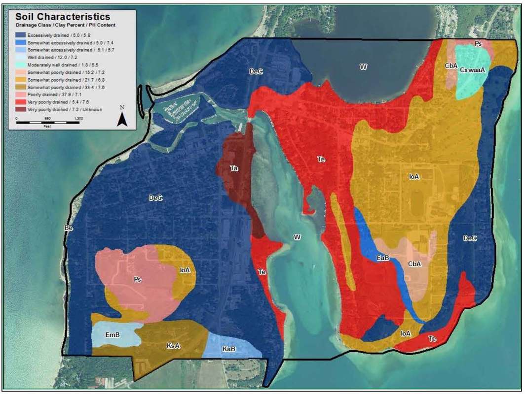
Figure 6. Elk Rapids soil characteristics.
The soil characteristics map (Figure 6), which shows soil type, percent of clay in the soil, pH, and drainage, can be used to help determine where trees can assist with decreasing flooding throughout the village. This map should be used in conjunction with the Recommended Tree Species List for Grand Traverse Bay to determine the appropriate trees to plant under the soil conditions available. This species list has been customized to include species that will be hardy in USDA Hardiness Zone 5 and trees that are available from the local nurseries. The list includes the root space needed, height at maturity, the soil characteristics, pH tolerance, salt tolerance, among other factors to assist in choosing the “right tree for the right place.” The following list can be used as a general guide of good species to use for different purposes and soil issues:
Trees adapted to floodplains and swamps can be used for poorly drained, heavy clay, or severely compacted soils. Examples include:
- River birch
- Freeman maple
- Swamp white oak
- Eastern hackberry
- Bald cypress (in wetter areas, at northern extent of range)
- Dawn redwood (at northern extent of range)
- Blackgum (at northern extent of range)
- Honeylocust (compacted, not necessarily wet)
- Kentucky coffee tree (compacted, not necessarily wet)
- Burr oak
Trees that occur in sandy soils are suitable for excessively drained, sandy, or droughty soils, such as:
- Red pine
- Jack pine
- White oak
- Smooth sumac
Trees with large amounts of leaf surface area are great for stormwater capture or management, such as:
- Various oaks
- Black willow
- Cottonwood
- Freeman maple
- Red maple
- Hybrid elm
- Sycamore
- London planetree
Takeaway. The planting priority level map layer should be used in conjunction with the soil characteristics map layer (Figure 6) and finally with the recommended tree planting list to determine the best locations to plant trees first. Establishing ideal planting locations is important to maximize the benefits trees can provide to the community to reduce air pollution and flooding.
