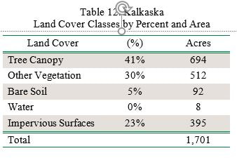
Kalkaska’s tree canopy (41%) is average compared to other Michigan communities. Other vegetation comprises 30% of the land cover. Impervious surfaces (buildings and roads) make up 23% of the land cover. The outskirts of the village—particularly in the southern and northern areas—have the greatest canopy cover, while the commercial areas along Cedar Street, Dresden Road, and Mile Road have the greatest amount of impervious area (Figure 7).
All maps for this village can be found in the Story Map. Some of the maps are illustrated below to feature village canopy interests.
All maps for this village can be found in the Story Map. Some of the maps are illustrated below to feature village canopy interests.
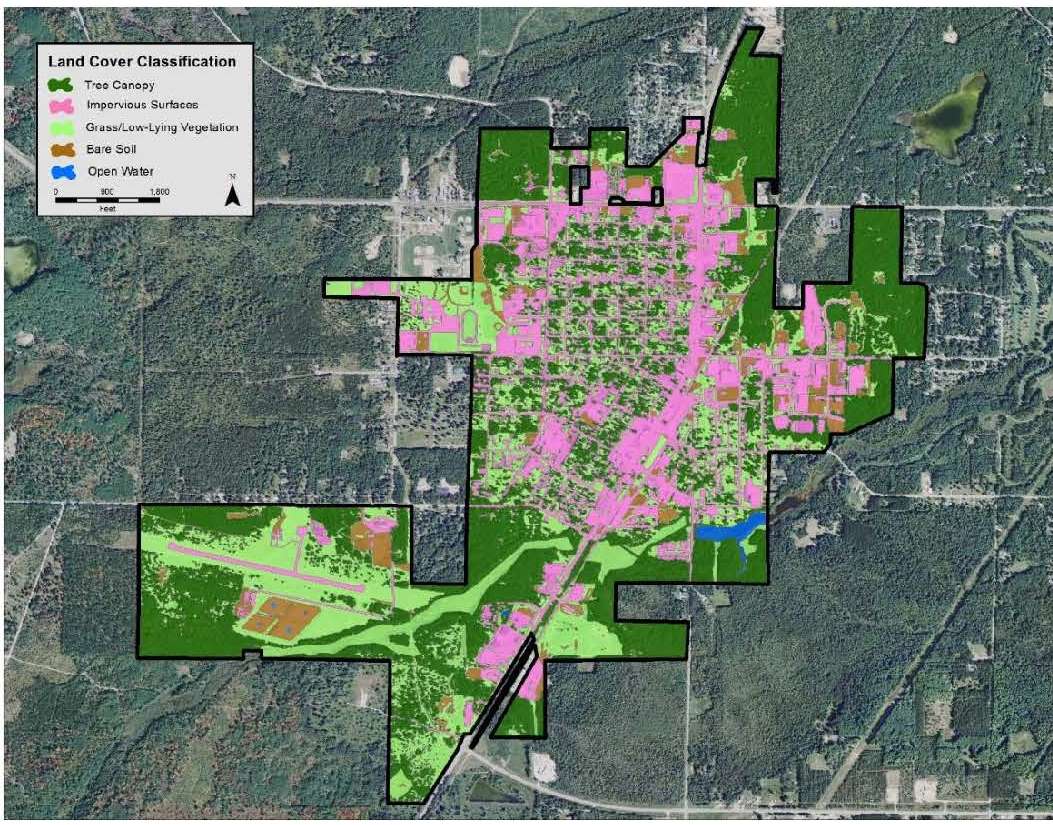
Figure 7. Kalkaska land cover classification.
When examining canopy in the ROW, some of the streets with the least canopy include Cedar Street, Dresden Street, and Mile Road. The areas in the ROW that contain the highest priority levels for tree planting are concentrated to the residential blocks located to the north and south of Lynn Street, as well as the area near the Kalkaska Public works building on South Cedar Street.
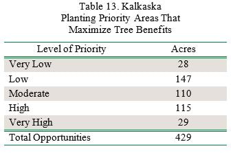
The planting priority levels layer can be used to focus in on the locations in which plantings may deliver the most benefits in terms of ecosystem benefits and overall benefits to the community. Kalkaska can use this as a guideline for deciding where future trees can be planted to have the greatest impact on benefits and stormwater runoff. Of the 429 acres, 33% of those acres (144 acres) are listed as Very High or High planting priority. If only the Very High and High priority planting areas are planted, Kalkaska could achieve 49% tree canopy.
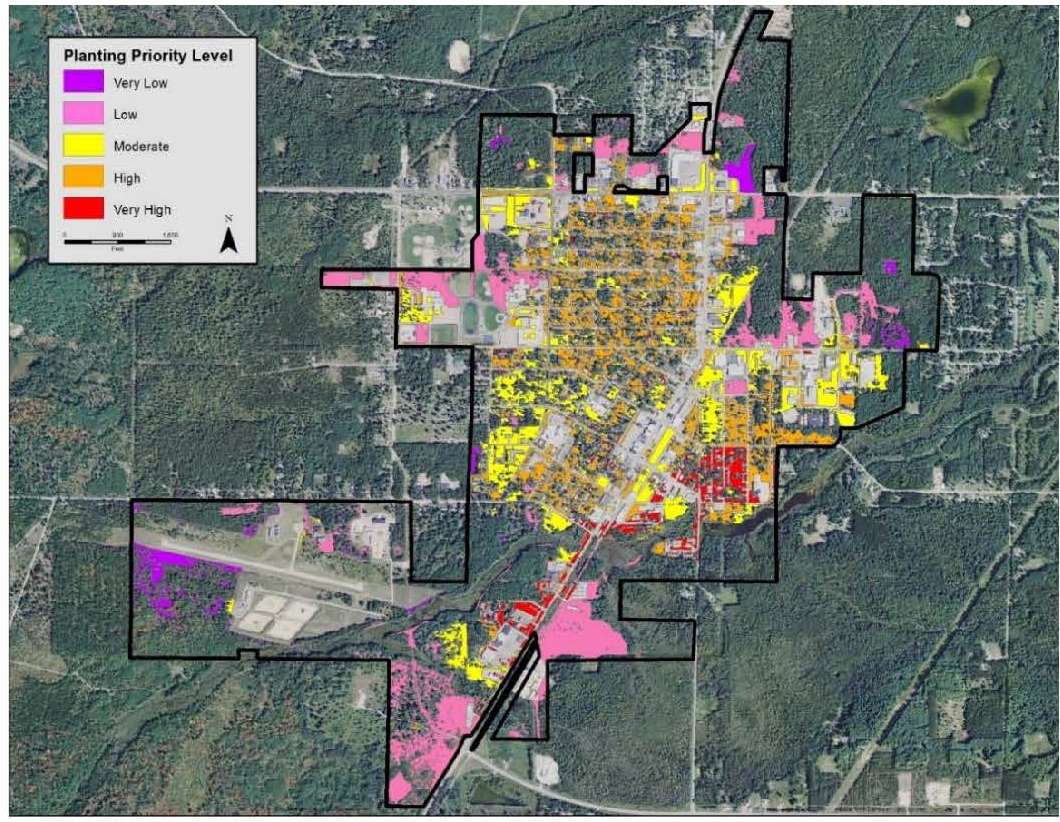
Figure 8. Kalkaska prioritized planting areas.
The tree canopy percent by census block analysis (Figure 5) can be used a supplemental tool to determine which neighborhoods are in most need of planting (Figure 9). For Kalkaska, the tree canopy percent by census block analysis largely confirms the results of the planting priority analysis, where it is shown that the commercial areas south of Dresden Road and along South Cedar Street are in highest need of tree canopy cover. The tree canopy percentage ranges from 0% to 30% in many of the census blocks in these areas.
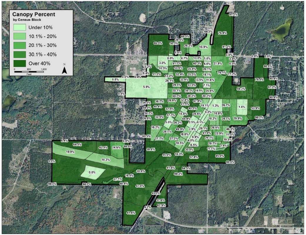
Figure 9. Kalkaska tree canopy percent by census block.
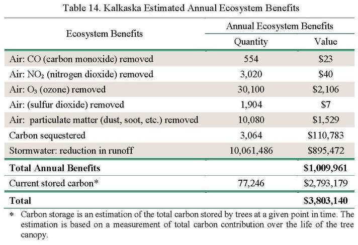
Community forests are important components of the ecosystem by virtue of the quantifiable benefits they provide. Kalkaska realizes an annual benefit of $1,009,961 for reductions in air pollution, stormwater reduction, and carbon sequestration from the tree canopy (Table 14). The village also benefits from carbon stored in the trees. Carbon storage provides a benefit of $2,793,179 over the lifetime of the trees.
The 2015 windstorm that went through the Grand Traverse Bay especially affected the canopy cover in the Village of Kalkaska. Land cover results from the 2016 UTC analysis were compared to 2014 NAIP data to determine the changes in land cover classification. This comparison yields a historic UTC change assessment between these two years. Figure 9 illustrates tree canopy changes between 2014 and 2016. Results of the land cover change analysis from 2014 to 2016 are reported in Table 15.
Between 2014 and 2016, the Village of Kalkaska lost 0.6% of tree canopy, decreasing from 41.03% to 40.8%. There were small canopy losses throughout the village in many parts of the residential and commercial areas. The highest areas of loss can be found on a wooded edge of the village along West Street on the southern end of the village on Cedar Street, and at a commercial development at a site north of Dresden Road.
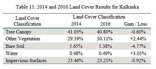
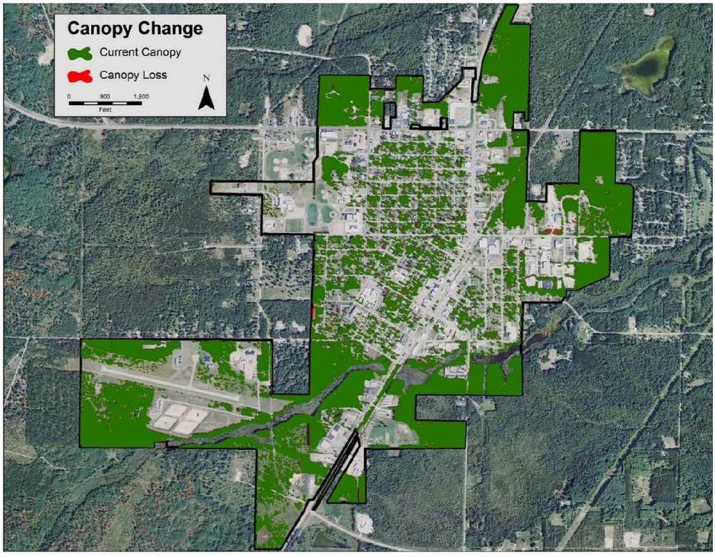
Figure 10. Kalkaska 2014-2016 canopy change.
Takeaway. To increase canopy throughout Kalkaska, areas identified as “Very High” and “High” planting priority should be the initial focus of plantings as well as areas that suffered canopy loss during the 2015 windstorm. In the neighborhoods where tree canopy was lost, the village can discuss with property owners the value of tree canopy and can prioritize the areas to plant utilizing the planting priority maps to determine the best locations to increase canopy.
Takeaway. To increase canopy throughout Kalkaska, areas identified as “Very High” and “High” planting priority should be the initial focus of plantings as well as areas that suffered canopy loss during the 2015 windstorm. In the neighborhoods where tree canopy was lost, the village can discuss with property owners the value of tree canopy and can prioritize the areas to plant utilizing the planting priority maps to determine the best locations to increase canopy.
